Connect with us

WORLD INFO

All You Need to Know About Continents: Facts and More

Published

on

ASIA CONTINENTS

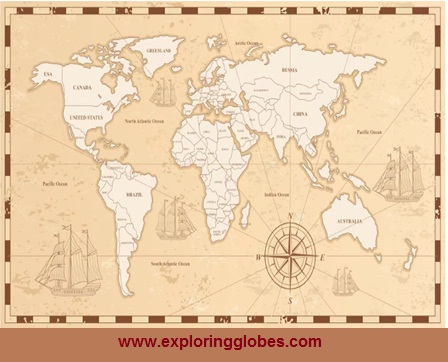
A continent is defined as one of the larger area or large continuous or vast or great division of landmasses of the globe including both dry land and continental shelves or land separated by large water bodies. Earth surface has seven largest to smallest continents (chronologically) such as:

1. Asia

2. Africa

3. North America

4. South America

5. Antarctica

6. Europe

7. Australia /Oceania

World Map

Credit -Freepik -amanitasilvicora

These continents make up a total of 57 million square miles of land.

The more than two-thirds of the earth’s surface is covered by water. Asia and Africa are the two biggest continents.

How were the continents formed ?

Through the movement of tectonic plates, over million years ago the world seven continents have been formed.

Formation of Continents

Important Geophysical Phenomena

In Context

A recent study that appeared in the journal Nature suggests that the continents on Earth may have formed as a result of massive meteorite impacts.

More about the study

According to the study, Earth’s continents were formed by massive meteorite impacts that were common during the first billion years of our planet’s four and a half billion-year history.

Meteorite impacts released enormous amounts of energy, resulting in the formation of oceanic plates, which later evolved into continents.

The process:

According to the study, the giant meteorite hit Earth and melted the outer shell of the Earth, or the lithosphere, releasing pressure on the underlying mantle. As a result, the mantle melted, resulting in an oceanic plateau.

Significance:

• Earth is the only planet known to have continents, and scientists are fascinated by the evolution and formation of the continents, making it the most researched field among planetary scientists.

• It is well known that numerous such impacts have hit the planet since archaic times, but this research provides the first solid evidence that the processes that eventually formed the continents began with giant meteorite impacts, similar to those responsible for dinosaur extinction but occurring billions of years earlier.

• Understanding the formation and evolution of continents is important because it is the key to reserves of metals such as lithium, tin, and nickel, which are required to develop batteries, according to the study.

Meteorites impact other planets as well, so why is this phenomenon unique to Earth?

By the time the flux of effects decreased, other rocky planets and the moon had little or no water.

• An impact event occurs when two astronomical objects collide and cause measurable effects. Impact events have physical consequences and are observed on a regular basis in planetary systems, though the most common involve asteroids, comets, or meteoroids and have little effect.

• Significant physical and biospheric consequences can occur when large objects collide with terrestrial planets like Earth, though atmospheres mitigate many surface impacts through atmospheric entry.

Major impact events have shaped Earth’s history, playing a role in the formation of the Earth- Moon system and the evolution of life.

The origin of water on Earth, as well as a number of mass extinctions.

Plate Tectonic Theory

Alfred Wegener developed this concept from the 1950s to the 1970s, the hypothesis of plate tectonics is the cutting edge update to mainland float, a thought originally proposed by researcher Alfred Wegener in 1912 which expressed that World’s landmasses had “floated” across the planet over the long haul.

Wegener didn’t have a right clarification for how landmasses could move all over the world, yet specialists do now.

The Earth has a rigid outer layer known as the lithosphere, which is typically about 100 km (60 miles) thick and sits on top of a plastic (moldable, partially molten) layer known as the asthenosphere.

Plate tectonics is the hypothesis that World’s external shell is partitioned into enormous chunks of strong stone, called “plates,” that skim over Earth’s mantle, the rough inward layer over Earth’s center.

Earth’s strong external layer, which incorporates the covering and the highest mantle, is known as the Lithosphere.

Below the lithosphere is the asthenosphere — a thick layer kept flexible by heat profound inside the Earth.

It greases up the undersides of Earth’s structural plates, permitting the lithosphere to move around.

The Earth’s Lithosphere is partitioned into seven very large continental and ocean-sized plates, six or seven medium-sized regional plates, and a few small plates.

These plates move in relation to one another.

They move at a rate of 5 to 10 cm (2 to 4 inches) per year and interact along their borders.

They converge, diverge, or pass each other.

 Major Plates:

The Antarctic   Plate (and its surrounding oceanic plate).

The Plate of North America (with western Atlantic floor separated from the South American plate along the Caribbean islands).

The South American Plate (which is separated from the North American Plate by the Caribbean Islands).

The   Plate of the Pacific.

The Plate between India, Australia, and New Zealand.

Africa, including the eastern Atlantic floor Plate.

Eurasia and its neighboring oceanic Plate.

Minor plates of note include:

Cocos Plate: Located between Central America and the Pacific Plate.

South America and the Pacific Plate is located between the nazca plate.

Arabian Plate: The landmass of Saudi Arabia.

The Philippine Plate is located between the Asiatic and Pacific plates.

Caroline Plate: Located north of New Guinea, between the Philippine and Indian plates.

The Fuji Plate is located to the north-east of Australia.

Juan de Fuca Plate: Located south-east of the North American Plate.

Three types of tectonic boundaries are formed by the movement of the tectonic plates:

Convergent plates move into one another

Divergent plates move apart.

Transform, in which plates move sideways relative to one another.

Plate Boundaries

Mountain formation:

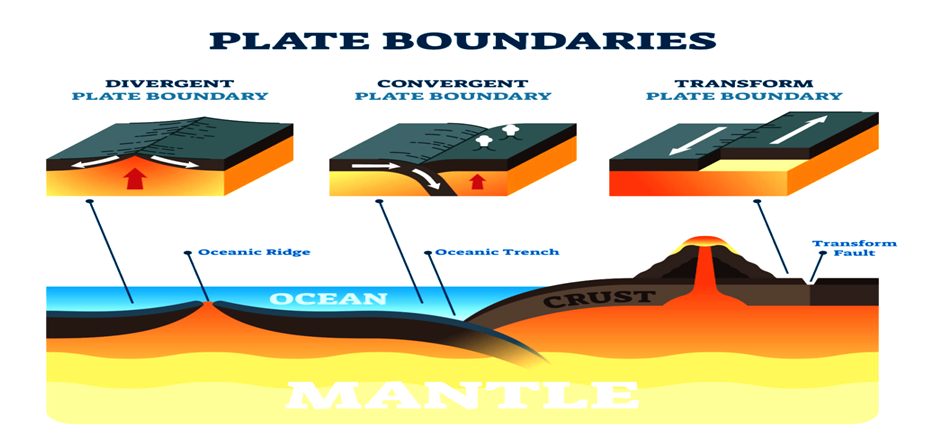
Mountain formation is caused by plate motions where plates push together or converge.

Ocean formation:

Oceans form where plates pull apart or diverge, and continents fracture.

The continents are embedded in the plates and drift passively with them, resulting in significant changes in the Earth’s geography over millions of years.

 Although earthquakes and volcanoes can occur in plate interiors, such interactions are thought to account for the majority of Earth’s seismic and volcanic activity.

Evidence of Plate Tectonic Theory:

• Continent Puzzle: Pangaea is formed by the continents fitting together almost like puzzle pieces (one super-continent).

Prehistoric evidence:-

Fossils from different continents are similar to fossils from previously connected continents.

Different life forms evolved as the continents separated.

Rock distributions: The majority of rock distributions within the Earth’s crust, including minerals, fossil fuels, and energy resources, are a direct result of the history of plate motions and collisions, as well as the corresponding changes in continent and ocean basin configurations.

Formation of Continents :–

Physical Geography

Important Geophysical Phenomena

Why in News?

As per another review, the world’s landmasses were shaped by enormous shooting star influences that were common during the initial billion years of our planet’s four and a half billion-year history.

What are the Highlights of the Study?

About:

Meteorite influences created enormous energy to frame maritime plates, which later advanced into landmasses.

The hypothesis that goliath shooting star influences framed mainland’s had been around for quite a long time, however as of recently, there was minimal strong proof for its help.

The Current hypothesis is the most regularly acknowledged hypothesis set up that credits mainland development to the development of structural plates.

Proof for Shooting star Effect Hypothesis:

Zircon crytals in Pilbara Craton: The analysts searched for proof in zircon precious stones implanted in rocks from the Pilbara Craton in Western Australia. This craton is the leftover of an old outside layer that started shaping multiple a long time back.

Zircons are shaped by the crystallization of magma or are tracked down in transformative rocks.

They go about as minuscule time cases, recording the time of geologic movement. Fresher zircon adds to the first gem over the natural course of time.

The investigation of the variations or isotopes of oxygen inside these gems i.e., oxygen-18 and oxygen-16 and their proportion assisted with assessing past temperatures.

Older grains of zircon had the lighter oxygen-16. The more youthful ones contained the heavier oxygen-18.

Cratons: A craton is an old and stable piece of the mainland lithosphere, which comprises of Earth’s two highest layers, the covering and the highest mantle.

Need for Understanding the Formation of Continents:

Understanding the arrangement and development of landmasses is significant, as it is the way to stores of metals like lithium, tin and nickel.

Most of Earth’s biomass and most people live on these bodies of land, so understanding how mainland’s structure and advance is essential.

Continental Drift Theory:

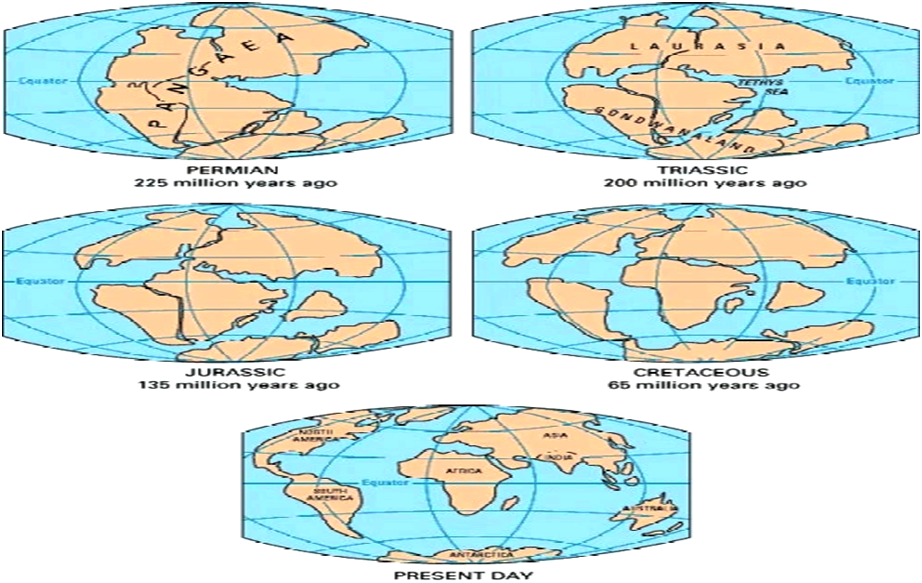
1. Continental drift theory is concerned with the distribution of oceans and continents.

 2. Alfred Wegener, a German meteorologist, proposed it first in 1912.

 3. According to the theory, all of the continents formed a single continental mass called Pangea, which was surrounded by a massive ocean called Panthalassa.

 4. Around 200 million years ago, Pangaea began to split into two large continental masses known as Laurasia and Gondwanaland, which formed the northern and southern components, respectively.

 5. Laurasia and Gondwanaland subsequently split into the various smaller continents that exist today.

The breakup of the Pangaea Supercontinent over time.

Prominent Evidence in Support of Continental Drift Theory

• South America and Africa appear to fit together, particularly the eastern bulge of Brazil, which appears to fit into the Gulf of Guinea and Greenland appears to fit in with the Ellesmere and Baffin islands.

• The west coasts of India, Madagascar, and Africa appear to be appropriate.

• The Mid-Atlantic Ridge is formed by North and South America on one side and Africa and Europe on the other.

Alfred Wegner studied ancient plant and animal fossils, geographical features on the continent’s borders, and mineral resources, and discovered similar results on the boundaries of other continents.

What is the purpose of capital in all nations?

You may wonder why nations require capital in the first place. What is the importance of a capital city?

 The term ‘capital’ is derived from the Latin caput, which means ‘head’.

The capital of a country serves as the state’s highest point.

 It is an excellent community for any administration-related administrations or offices.

Individuals sitting in the capital, which represents power, largely constrain the organisation of the nation.

Nauru is the only country on the planet without a government capital.

It was previously known as Wonderful Island. It is the third-smallest country in terms of region and the second-smallest in terms of population. Whatever the case may be, Yaren.

Nauru, an island in the Pacific Ocean, is the world’s second-smallest republic—but it lacks even a capital city.

Land and seas:

The beach is located where the land meets the ocean. It gets even more interesting beyond the beach. The beach is a minor component of the Continental Shelf, which is a broad, relatively shallow underwater terrace that forms part of the continental crust.

As you move away from the coast, you will come to a cliff at the end of the terrace. The slope is known as the Continental Slope, and it runs from the shelf to the ocean floor. Following the underwater scarp leads to the Abyssal Plain, a vast flat seafloor area hundreds of kilometers wide and thousands of kilometers long, at depths ranging from 3,000 to 6,000 meters (10,000 to 20,000 feet).

Coastal Zone with coastal plain (on land), continental shelf (under water), continental slope and abyssal plain.

Land Transfers

Plate tectonics is the process by which continents move. During this process, the Earth’s rigid outer shell, the lithosphere, glides over the asthenosphere, the hot upper layer of the Earth’s mantle, which is rather soft, highly viscous, and less dense.

Image showing land transfers in Earth

The Origin of Continents:

It takes a long time for continents to form; it takes millions of years. The lithosphere’s various plates move at a rate of 3 to 20 cm (1 to 8 inches) per year relative to one another. The forces that cause continents to move across the Earth’s surface are not completely understood.

Theory 1: Large scale convection currents in the mantle generate enough power to move the plates due to the heating and cooling of mantle matter.

Theory 2: Plumes, jets of partially molten rock material rising to the Earth’s surface between mid-ocean ridges, adding matter to the crust and pushing the plates in opposite directions.

At oceanic ridges, tectonic plates may move apart, collide at subduction zones, or slide past one another along fault lines.

New’ Continents:-

Te Riu-a-Mui in Zealandia

Zealandia is a portion of a continent that is mostly underwater in the Pacific Ocean and was formerly a component of Gondwana. It split from Australia between 60 and 85 million years ago. Australia’s size is roughly split in half by Zealandia. The parts of the continent that are not under water are called New Zealand, together with its neighboring islands, New Caledonia, and some Australian island territories like the Lord Howe Islands and Norfolk Island.

Even though Zealandia only has a few islands, geologists from New Zealand, New Caledonia, and Australia determined that it meets all the criteria to be classified as a continent* and would be the tiniest continent in the entire globe.

 A vast, continuous, distinct mass of land is referred to as a continent.

Mauritia

The island of Mauritius was formed by volcanic activity about 8 million years ago, making it relatively young geologically.

Yet, the discovery of old zircons on the island—about 3,000 million years old and far too old to be from the island—suggests the existence of a “lost” continent beneath Mauritius.

Mauritius is located at the southern extremity of the Mascarene Plateau, which resembles a continental shelf but doesn’t have a continent, according to a chart of the area’s ocean floor.

The Seychelles archipelago is located near the northernmost point of the plateau. Granite rock, which is extensively dispersed throughout the continental crust, makes up several of its islands.

 Mauritia is thought to have been a small, wedged-in continental piece.

There are how many continents in the world?

Six continents, however there is no accepted definition of how many there are. Many children in Europe learn about the six continents, which include one America made up of both North and South America. These six Australia/Oceania, Asia, Africa, America, and Antarctica continents are six .

There are at most seven continents, which are Africa, Antarctica, Asia, Australia/Oceania, Europe, North America, and South America.

Today, many scientists and geographers refer to six continents, combining Europe and Asia.

Oceania—is it a continent?

Actually, the South Pacific Islands of Oceania aren’t a continent under the definition of a continent as a sizable continuous stretch of land. Even yet, one may still claim that they are part of a continent; for instance, Oceania is occasionally considered a part of Australia’s continent.

The Olympic Rings, a symbol for the five (inhabited) continents of the world: Oceania/Australia, Africa, America, Asia, and Europe.

 The modern Olympic Games’ “father,” Pierre de Coubertin, created the rings in 1912.

The roots of the continent’s name.

The origins of the names for the continents.

Continents:-

Land continens, the “constant land,” comes from the Latin “continere,” and that signifies “to keep intact.”
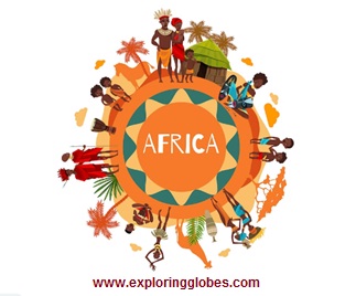
Africa:

The northern region of Africa, known as Africa Terra (Latin for “African Land”), was a component of the Roman Empire. Roman Latin’s transliteration of the Phoenician word Afryqah, which means “colony,” suggests that the Roman name may have its origins there.

The USA:

Amerigo Vespucci, an Italian navigator who made two (or four) voyages to America with Spanish and Portuguese expeditions, provided the inspiration for the term America, which was first used in 1507 by the cartographer Martin Waldseemüller in his work “Cosmographiae Introductory.” Vespucci was the first to understand that America was a separate continent from Asia.

Asia:

Latin and Greek beginning – the “Eastern Land,” it is guessed to be from the word asu “to go out, to ascend,” regarding the sun, in this manner “the place that is known for the dawn.”

Australia:

Latin – Land Australis incognita the “Obscure Southern Land,” a fanciful, speculative mainland, a huge body of land in the south of the Indian Sea, the alleged partner of the Northern Side of the equator.

Europe:

Latin and Greek beginning. Europe, Europe, frequently made sense of as “expansive face,” from eurys “wide” and operations “face.” Some recommend a potential semantic beginning by the Sumerian expression erebu with the significance of “murkiness” and “to go down, set” (concerning the sun), which would resemble Situate.

Oceania:

From the French Expression Oceanie, the southern Pacific Islands and Australia imagined as a mainland”.

Antarctica:

Old French: antartique, in Current Latin: antarcticus, in Greek: antarktikos, from against: “inverse” + arktikos: “of the north.”

Continue Reading
2 Comments

2 Comments

  1. Cheapest Private Proxies

    April 14, 2023 at 9:21 am

    This is very interesting, You’re a very skilled blogger. I have joined your rss feed and look forward to seeking more of your great post. Also, I have shared your web site in my social networks!

Leave a Reply

Your email address will not be published. Required fields are marked *

WORLD INFO

The World’s Oceans

Published

on

What are the oceans of the world?

A body of water that is mostly salt water is called an ocean. It covers nearly 70% of the surface of the Earth. Seas comprise of somewhat more than 95% of the world’s all’s water. Although a sea is a part of an ocean, land typically surrounds it in part. Additionally, oceans are much deeper and larger than seas.

The five oceans that make up the surface of our globe are the Pacific Ocean, the Atlantic Ocean, the Indian Ocean, the Southern Ocean, and the Arctic Ocean.

credit -Freepik

The Pacific Ocean

Credit – Freepik

The Pacific Ocean, which accounts up more than 30%, or one-third, of the planet’s surface, is the largest ocean in the world.

 Oceans cover almost half of the earth’s surface, and the Pacific Ocean’s size is greater than the sum of the areas of all the continents. It touches North America’s west coast. Challenger Deep is the name of the lowest known place on earth.

 It is situated at the end of the Mariana Trench in the Philippine Sea in the Pacific Ocean, close to Guam. At a depth of 36,037 feet, it is deeper than Mount Everest.The trench’s extraordinary depth is caused by its location at the intersection of two tectonic plates. Earthquakes frequently occur near the ocean’s coastline in Japan and North America.

The ocean was given its name by intrepid traveller Ferdinand Magellan. He described a “calm sea” by using the word “pacific.”As a result, Pacific Ocean is an ocean of peace. But, the Pacific is not entirely calm and serene.

The Pacific Ocean is the location of the “ring of fire”. The Ring of Fire, a chain of 450 volcanoes in a U – shape, is located in the Pacific Ocean. They stretch from South America through New Zealand, along the coast of Japan, and the western United States, all the way down to the equator.

Since the Pacific basin is home to a number of still-active volcanoes, it frequently experiences large earthquakes and volcanic eruptions.

The Great Barrier Reef, which sits off the coast of Australia, is the biggest coral reef in the world.

The Atlantic Ocean

Credit -Freepik

Between the continents of America, Europe, and Africa is the second-largest ocean in the world, the Atlantic.

20% of the Earth’s surface is covered by the Atlantic Ocean, which is about half as large as the Pacific Ocean. Yet, as it moves along the Mid-Atlantic Coasts, it is expanding in size.

Is believed to have developed during the Jurassic Era. Moreover, it has connections to the Atlantic, Pacific, Arctic, and Southern Oceans. The Northern Atlantic and the Southern Atlantic are separated by the equator.

The majority of the geological activity in the Atlantic Ocean, which is regarded as a passive margin ocean, is concentrated in the Mid-Atlantic Ridge. The vast majority of its coastline areas are low and geologically unactive.

The Mediterranean Sea, the North Sea, the Baltic Sea, Hudson Bay, the Gulf of Mexico, and the Caribbean Sea are some of the major marginal seas of the Atlantic. The Atlantic is 82 million square kilometres in size (32 million square miles). It is 3,600 metres deep on average (11,812 feet). Its deepest point is 8,605 metres in the Puerto Rico Trench (28,231 feet).

The seas of the Atlantic are home to sharks, like this Thresher Shark swimming in the Gulf Stream. The ocean is home to a diverse variety of marine life, including organisms that live more than 3,000 feet below the surface and turtles and dolphins. The largest island in the world, Greenland, is oddly situated between the Atlantic and Arctic Oceans.

The Indian Ocean

Credit – Freepik

Third large ocean in the globe is the Indian Ocean. It includes a number of tropical islands and occupies around 1/5 of the surface of the planet. Africa forms the ocean’s northwest border, followed by Antarctica, India, and Asia in the north, and Australia in the east. The Arabian and Laccadive Seas are part of it.

The world’s warmest ocean is the Indian Ocean. This implies that a wide range of marine organisms cannot survive in its warmer waters. Surprisingly, some of the most significant ports in the world, such those in Mumbai and Kolkata, can be found on the sea.

The Indian Ocean is the smallest of the three major oceans, with a surface area of 73 million square kilometres (28 million square miles), or about 20 percent of the total ocean surface area. 3,890 metres is the average depth of the Indian Ocean (12,762 feet). The Java trench is its deepest point, measuring 7,725 metres.

The Indian Ocean’s waters serve as the largest humpback whale breeding grounds in the entire planet. A fish that was believed to be extinct was also found in the Indian Ocean. Between Mozambique and Madagascar, in the warm seas off the Comoro islands, the coelacanth can be found.

Because to its connection between Asia and the Middle East’s oil-rich nations, the Northern Indian Ocean is also crucial for the transportation of oil. On its waterways, tankers transport 17 million barrels of crude oil daily from the Persian Gulf.

The Southern Ocean

Credit -Freepik

In the Southern Hemisphere, off Antarctica, the Southern Ocean is situated near the South Pole across from the Antarctic Circle.

The Southern Ocean is currently the fourth-largest ocean in the planet (after the Pacific Ocean, Atlantic Ocean, and Indian Ocean, but larger than the Arctic Ocean). 24,390 feet, or 7,434 metres, is the depth at which the ocean is deepest. Climate change has caused its ecosystem to shift significantly in recent years. Animals like seals, penguins, and orcas live in the waters.

Wandering albatrosses and Emperor Penguins both reside in the Southern Ocean.

The Arctic Ocean

Credit -Freepik

5.427 million square miles (14,055,865 square kilometers)

Around the North Pole, beyond the Arctic Circle, is where you’ll find the Arctic Ocean.More than five times smaller than the Indian and Atlantic oceans, the Arctic Ocean is the world’s tiniest ocean and is recognized as the coldest of all the oceans with the lowest salinity. Compared to other oceans, sealife is considerably more difficult to observe.

Polar bears can be found in large numbers on the Arctic ice.

A jellyfish known as the ‘Lion’s Mane Jellyfish’ can also be found in the Arctic Ocean. It can grow to be 2.4m (8 ft) broad and feeds on plankton and fish. Through a narrow, shallow waterway known as the Bering Strait, it is connected to the Pacific Ocean.

RankOceanRemark
1Pacific OceanSeparates Oceania and Asia from the Americas
2Atlantic OceanSeparates the Eurasia and Africa from Americas
3Indian OceanSpreaded upon southern Asia and separates Africa and Australia
4Southern OceanIt encircles Antarctica, considered an extension of the Pacific, Atlantic and Indian Oceans
5Arctic OceanA sea of the Atlantic, which washes upon northern North America & Eurasia and covers much of the Arctic
Oceans in the world
Continue Reading

ANTARCTICA

All You Need to Know About Continents : Antarctica

Published

on

Facts about Antarctica

  • By population, Antarctica is the smallest continent. As a result, the vast continent is only sparsely populated.

 • On Antarctica, there are only temporary research stations for scientists, and the land is almost entirely covered by ice.

  •  This continent, which accounts for 60% to 70% of the world’s freshwater supply, is home to 90% of the planet’s ice.

• 75% of the world’s ice and 70% of the planet’s fresh water are found in Antarctica, making it not only the coldest spot on Earth, but also the highest, driest, windiest, and emptiest.

  •  The White Continent or the Ice Continent are other names for it. Antarctica was referred to as “Terra Australis Incognita” prior to 1840, which was Latin for “the undiscovered southern land.”

• In Antarctica, the winter months of late March to late September are completely dark during the day, while the summer months of December to February provide 24 hours of light.

• The Ice Continent has summertime lows of roughly -35 degrees Celsius in the interior and 2 degrees Celsius in its coasts. In the winter, the interior registers -70 degrees Celsius while the beaches register 2 degrees.

• At -89 degrees Celsius, Antarctica was the lowest natural temperature ever measured on Earth.

• As a result of these significant temperature swings, the creation of ice along Antarctica’s periphery makes the continent’s wintertime area approximately 14.2 million square kilometers bigger than its summertime area.

• There are no time zones on this continent, and nothing can rot in the frigid waters of Antarctica.

  • The Belgica Antarctica bug, which has a length of 1.3 cm, is the largest land animal in Antarctica.

• Penguins call Antarctica home, and Adelie penguins are the most prevalent species here. The only permanent populations in Antarctica are the research bases where experts from many nations come to work.

The Antarctic Circle is shown on the map, and Antarctica is the fifth-largest continent by area after Asia, Africa, North America, and South America. Antarctica has a land area of 14 million km2, of which 280,000 km2 are ice-free and 13.72 million km2 are covered in ice.

The South Pole, which is customarily the southernmost point on Earth’s surface, is not nearly in the centre of Antarctica (wherever you would go from here you would go north, somehow).

 One of the ends of the Earth’s rotation axis is the South Pole. Because Earth rotates slightly off-center, the South Pole is not actually a fixed location.

 Scientists refer to this phenomenon as the Polar Motion; it is the movement of Earth’s rotational axis over its “surface,” and the deviation is only a few metres.

 South Africa, Australia, New Zealand, Chile, and Argentina are the nations that are closest to Antarctica.

There are no towns or communities on Antarctica because ice blankets 98% of the land.

The map also identifies the locations of scientific research facilities run by several nations across the continent.

Continue Reading

AMERICAS

All You Need to Know About Continent : THE AMERICAS

Published

on

Facts about the North Americas

NORTH AMERICA:

1. The entire northern and western hemispheres are home to the continent of North America.

2. The continent of North America is home to 23 nations. The largest nation in North America is Canada, the second-largest nation in the globe and the northernmost nation on the continent. The largest economy in the world, the United States of America, is contained there.

3. Greenland, the largest island in the world, is situated on the continent of North America. Yet, the European nation of Denmark is the owner of Greenland. The northernmost location in the world is also associated with Greenland.

4. On the continent of North America, there are about 580 million people. The world’s largest concentration of Christians lives in North America. About 80% of the populace of Canada, the United States, and Mexico identify as Christians.

5. North America has five time zones and is the only continent with every type of climate.

6. It was named after the explorer Americo Vespucci and is also known as the “New World.”

7. Of the seven continents in the world, North America has the highest population density (22.9 people per square kilometer).

8. The largest freshwater lake in the world is Lake Superior in North America.

9. North America is home to the Mississippi River, the third-longest river in the world (3778 km), the continent with the greatest average per-person income among the continents, and the one with the highest average food intake.

10. North America includes the USA, which has the greatest economy in the world.

11. North America is the world’s top producer of soyabeans, maize, and other crops.

12. This continent is home to the Elf, the tiniest owl in the world.

13. The moose and the elk, found in North America, are the first and second tallest mammals on the continent.

14. Cuba, known as the “sugar bowl of the world,” is the world’s greatest exporter of sugar among the seven continents.

15. Hummingbirds, brown bears, bald eagles, bullfrogs, and brown bears are among the numerous notable animals found in North America.

Have a look at the list of North American nations and their capitals.

SL.No.North-America CountryCapitalCurrency
1Antigua and BarbudaSt. John’sEast Caribbean Dollar
2BahamasNassauBahamian Dollar
3BarbadosBridgetownBarbadian Dollar
4BelizeBelmopanBelize Dollar
5CanadaOttawaCanadian Dollar
6Costa RicaSan JoseCosta Rican Colon
7CubaHavana2 currencies – Cuban Peso and Cuban convertible peso
8DominicaRoseauEast Caribbean Dollar
9Dominican RepublicSanto DomingoDominican Peso
10El SalvadorSan SalvadorUS Dollar
11GrenadaSt. George’sEast Caribbean Dollar
12GuatemalaGuatemala CityGuatemala Quetzal
13HaitiPort-au-PrinceGourde
14HondurasTegucigalpaLempira
15JamaicaKingstonJamaican Dollar
16MexicoMexico CityMexican Peso
17NicaraguaManaguaCordoba
18PanamaPanama CityUS Dollar (Panama locals call it Balboa)
19Saint Kitts and NevisBasseterreEast Caribbean Dollar
20Saint LuciaCastriesEast Caribbean Dollar
21Saint Vincent and the GrenadinesKingstownEast Caribbean Dollar
22Trinidad and TobagoPort of SpainTrinidad and Tobago Dollar
23United StatesWashington, D.C. *US Dollar

El Salvador’s previous currency was the Colon, but in 2001 the US Dollar took its place.

Washington, D.C., is referred to as the “District of Columbia.”

The location of Washington is in this district. George Washington, a former US president, is honoured by the city’s name.

 The District of Columbia is a federal district rather than a state (which means it is directly under the control of the federal government).

During the American Revolution, the word “Columbia” was used to refer to the US in a patriotic manner.

Credit -Freepik

 SOUTH AMERICA:

 Details about the South Americas

1. The continent of South America is home to 12 separate nations.

2. With about 214 million people, Brazil is the largest and most populated nation in the continent.

3. This represents roughly half of the population of the continent.

4. Due to its size, Brazil has borders with nearly all of the other nations on the continent.

5. Sao Paolo, the largest city in the region with a metropolitan population of approximately 12 million, makes up five of South America’s ten largest cities, making Brazil even more populous than some South American countries.

6. South America is a continent of numerous natural marvels, including the Andes, the world’s longest mountain range.

7. The Atacama Desert in Chile and the Angel Falls, the highest waterfalls on earth. South America has 430 million inhabitants.

8. South America is home to the highest waterfalls in the world, the Angel Falls, as well as the second-longest river in terms of length (6440 km), the Amazon.

9. The green anaconda, the second-longest snake in the world, is found in South America.

10. This continent is home to the two tallest volcanoes in the world, Mt. Cotopaxi and Mt. Chimborazo.

11. Brazil, the world’s largest coffee producer, is located in South America.

12. The largest salt lake in the world, Salar de Uyuni (also known as the Uyuni salt flats), is located in South America.

13. Lake Titicaca, the highest lake in the world (3800 m), is also the largest lake in South America.

14. The Andes are the second-highest mountain range in the world, behind the Himalayas.

15. South American terrain contains these young-fold mountains.

16. The tallest peak in the Andes is Mount Aconcagua (7,021 m).

Have a look at the list of south American nations and their capitals.

SL.No.South-America-CountryCapitalCurrency
1ArgentinaBuenos AiresArgentine Peso
2BoliviaSucreBoliviano
3BrazilBrasiliaReal
4ChileSantiagoChilean Peso
5ColombiaBogotaColombian Peso
6EcuadorQuitoUS Dollar
7GuyanaGeorgetownGuyana Dollar
8ParaguayAsuncionGuarani
9PeruLimaNuevo Sol
10SurinameParamariboSuriname Dollar
11UruguayMontevideoUruguay Peso
12VenezuelaCaracasBolivar
Credit – freepik

Other information about the Americas:

1 .Population The Americas are home to an estimated 998 million people, or 13% of the world’s population. Most populous Metropolitan Areas

2. The major cities in the Americas are: Los Angeles, New York, Buenos Aires, Mexico City, and So Paulo.

3. Highest Point At 6,960.8 metres, Argentina’s Aconcagua is the highest mountain in the Western Hemisphere (22,837 ft).

4. With a height of 6,168 metres, Denali in Alaska, commonly referred to as Mount McKinley, is the highest mountain in North America (20,239 ft).

5. Biggest Lake:-Lake Superior is the biggest lake in the Americas. It is the biggest Great Lake, and it is shared by the US and Canada. It is also the world’s largest freshwater lake, covering an area of 82,000 km2 (32,000 sq mi).

6. Lengthiest Rivers:-The Rio Amazonas (Amazon River), with a length of “at least” 6,400 km, is the longest river in the Americas (4,000 mi). The Peruvian portion of the Andes mountain range is where the Amazon River originates.

7. With a length of 4,880 km (3,030 mi), the Paraná is the second-longest river in the Americas. It passes through three nations—Argentina, Brazil, and Ocean.

8. Paraguay—before emptying into the Río de la Plata, an estuary in the Atlantic.

 Given that the name of the “primary river” changes, there is a lot of debate regarding the longest river in North America.

9. At a length of 4,087 km (2,540 mi), the Missouri is the longest river in North America. Its source is in the Rocky Mountains in western Montana.

10. The Mississippi River, which rises in Lake Itasca in Minnesota, USA, is the second-longest river in North America at 3,766 km (2,340 mi).

America’s Principal Geographical Features

North America, South America, Central America, and the Caribbean are the major sub-regions.

Mountains

The American Cordillera, a network of mountain ranges spanning North and South America as well as West Antarctica, is made up of the Pacific Coast Ranges, the Rocky Mountains, and the Andes.

Plateaus and shields

North America

North America’s Coteau des Prairies (in portions of South Dakota, Minnesota, and Iowa), Allegheny Plateau, Appalachian Highlands, Appalachian Plateau, Intermontane Plateaus with the Colorado Plateau and Columbia Plateau, Ozarks, and Yukon Plateau (Yukon Territory, Canada).

South America

The Brazilian Highlands, the Mato Grosso Plateau, the Guiana Highlands, the Altiplano (High Plateau in Bolivia), the Atacama Plateau, the Guiana Shield, one of the three cratons of the South American Plate, and the Pakaraima Mountains, with Mount Roraima, are the major plateaus in South America (at the tripoint of Venezuela, Guyana and Brazil).

Lowlands

There are a number of significant lowlands in the Americas, including the Great Plains (a portion of the Interior Plains of North America), which are found in the US and Canada, and the Atlantic coastal plain along the East Coast of the United States. The huge Amazon drainage basin, which takes up more than 35% of South America, is home to the lowlands of that continent. Uruguay, Argentina, and Brazil all share the fertile Pampas plains. Los Llanos (The Plains) is vast tropical grassland plain in Colombia and Venezuela, and the Gran Sabana (Big Savanna) is a sizable savanna region in Venezuela.

Deserts

One of the driest regions on earth is the Atacama Desert, which is located in Chile and Peru. The largest and tallest salt desert in the world is located in Bolivia’s Salar de Uyuni (Salar de Tunupa). The Great Basin Desert is one of the largest deserts in North America, while the Patagonian Desert is the largest in the Americas. The Chihuahuan Desert covers a sizable portion of southern USA and northern Mexico. Much of the southwestern United States and the northwest Mexican states of Sonora, Baja California, and Baja California Sur are covered by the Sonoran Desert, which is the hottest desert in both Mexico and the United States.

Lakes

Three of the Great Lakes of North America—Lake Superior, Lake Huron, and Lake Michigan—are among the largest freshwater lakes on the planet. Has an area of 8,372 km2. The biggest and safe lake in South America and world is Lake Titicaca.

Islands

Greenland, Baffin Island, Victoria Island, Ellesmere Island, Newfoundland, Cuba, and Hispaniola are the largest islands in the Americas.

American languages

When the Europeans arrived, the Americas were home to thousands of different languages. Spanish, English, Portuguese, some French and French-based creoles, and a few Amerindian languages are the main languages spoken in the Americas today.

Continue Reading

Trending

Copyright © 2017 Zox News Theme. Theme by MVP Themes, powered by WordPress.